Arap ülkelerindeki Dünya Mirasları
Bu liste, Arap Devletlerindeki Dünya Mirasları Listesidir.[1] Listedeki sitelerin bazılar coğrafi olarak Asya'da, bazıları ise Afrika'da yer almaktadır.
Liste
Tablonun üzerindeki sıralama butonuna basılarak ilgili kategori ile ilgili yeniden sıralama yapılabilir.
- Site – Dünya Miras Komitesi'nin resmi adından almıştır[2]
- Konum – sitenin yer aldığı ülke.
- Kriter – Dünya Miras Komitesi'nin belirlediği ölçütler[3]
- Alan – tampon bölgeler hariç, hektar ve acre olarak. Sıfır değeri, UNESCO tarafından hiçbir veri yayınlanmamış demektir
- Yıl – Dünya Mirasları Listesine eklenme tarihi
- Açıklama – Mevcutsa, site ile ilgili diğer bilgiler
† Tehlike altında
| Site | Görsel | Konum | Kriter | Alan ha (acre) |
Yıl | Açıklama |
|---|---|---|---|---|---|---|
| Beni Hammad Kalesi | 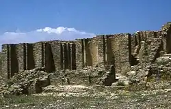 |
M'Sila Vilayeti, 35°49′6″K 4°47′13″D |
Kültürel: (iii) |
150 (370) | 1980 | Hammadid hanedanının ilk başkenti olan Beni Hammad Kalesi, 1007'de kurulmuş ve 1090'da terk edilmiştir. Cezayir'deki en büyük camilerin yanı sıra bir dizi saray ve sur duvarlarını içermektedir.[4] |
| Cuicul-Djémila | 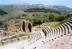 |
Sétif Vilayeti, 36°19′14″K 5°44′12″D |
Kültürel: (iii)(iv) |
31 (77) | 1982 | Djémila (eski adı ile Cuicul) dağlık bir yerleşimdeki, bir forum, tapınaklar, bazilikalar, zafer kemerleri ve dini yapılar ve her biri deniz seviyesinden 900 m (3000 ft) yukarıda bir yere adapte edilmiş diğer yapılardan oluşan bir Roma kentiydi.[5] |
| Cezayir Kasbahı |  |
Cezayir Vilayeti, 36°47′00″K 3°03′37″D |
Kültürel: (ii)(v) |
50 (120) | 1982 | Cezayir Kasbahı, Akdeniz sahilinde benzersiz bir İslam şehri. Kale, antik camiler ve Osmanlı sarayları kalıntıları içerir.[6] |
| M'zab Vadisi |  |
Gardaya Vilayeti, 32°29′00″K 3°41′00″D |
Kültürel: (ii)(iii)(v) |
4.000 (9.900) | 1982 | El değmemiş, geleneksel insanlık yaşam alanı, 10. yüzyılda M'zab Vadisi'nin beş ksarı çevresinde İbadiler tarafından inşa edilmiştir.[7] |
| Tassili n'Ajjer | 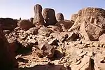 |
İlizi ve Tamanrasset Vilayetleri, 25°30′00″K 9°00′00″D |
Karma: (i)(iii)(vii)(viii) |
7.200.000 (18.000.000) | 1982 | Sahra'nın kenarında geniş bir plato olan Tassili n'Ajjer, M.Ö. 6.000'den I. yüzyıla kadar uzanan iklim değişiklikleri, hayvan göçleri ve insan hayatının gelişimini kaydeden 15.000'den fazla mağara gravürü içeriyor. Aşınmış kumtaşı yer şekilleri de dikkat çekicidir.[8] |
| Timgad | 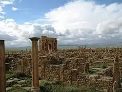 |
Batna Vilayeti, 35°27′00″K 6°38′00″D |
Kültürel: (ii)(iii)(iv) |
91 (220) | 1982 | İmparator Trajan tarafından M.S. 100'de askeri bir koloni olarak kurulan Timgad, Roma şehir planlamasına tipik bir örnek teşkil eden caddelere sahiptir.[9] |
| Tipasa | 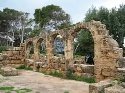 |
Tibaze Vilayeti, 36°32′00″K 2°22′00″D |
Kültürel: (iii)(iv) |
52 (130) | 1982 | Daha önce bir Kartaca ticaret merkezi olan Tipasa, Romalılar tarafından ele geçirildi ve bir askeri üs haline getirildi. Site ayrıca Hristiyan öncesi ve Bizans etkilerine de tanıklık yapıyor.[10] |
| Qalat al-Bahrain; Antik Liman ve Dilmun Uygarlığının Başkenti | 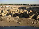 |
Kuzey Valiliği, 26°13′59″K 50°31′38″D |
Kültürel: (ii)(iii)(iv) |
32 (79) | 2005 | Qal'at al-Bahrain, Milattan Önce 2300'lerden günümüze kadar sürekli insan işgaline tanıklık eden Dilmun uygarlığının başkentiydi. Sitenin üstünde bir Portekiz kalesi duruyor.[11] |
| İncicilik, Bir Ada Ekonomisine Tanıklık | 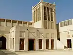 |
26°14′28″K 50°36′49″D |
Kültürel: (iii) |
35.087 (86.700) | 2012 | [12] |
| Abu Mena | 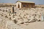 |
İskenderiye, 30°51′00″K 29°40′00″D |
Kültürel: (iv) |
183 (450) | 1979 | Eski Hristiyan kutsal kentinin kalıntıları bir kilise, bir vaftizhane, bazilikalar, kamu binaları, sokaklar, manastırlar, evler ve atölyeler içerir ve İskenderiye Menas'ın(?) mezarı üzerine inşa edilmiştir. |
| Teb Antik Kenti ve Nekropolü | 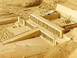 |
El Uksur, 25°44′00″K 32°36′00″D |
Kültürel: (i)(iii)(vi) |
7.390 (18.300) | 1979 | Mısır'ın eski başkenti ve Amun kenti Thebes, Karnak ve Luksor'da tapınaklar ve sarayların yanı sıra, Krallar Vadisi ve Kraliçeler Vadisi'ndeki nekropolleri de Mısır medeniyetinin yüksekliğine tanıklık ediyor.[13] |
| Tarihi Kahire Şehri | .jpg.webp) |
Kahire, 30°03′00″K 31°15′40″D |
Kültürel: (i)(v)(vi) |
524 (1.290) | 1979 | Dünyanın en eski İslam şehirlerinden biridir ve Kahire kentinin ortasında bulunur. Bölge 10. yüzyıldan kalmadır ve 14. yüzyılda altın çağına ulaşmıştır. Bölgede çeşitli camiler medreseler ve çeşmeler içerir. |
| Memfis ve Nekropolü; Giza'dan Dahshur'a Piramitler | 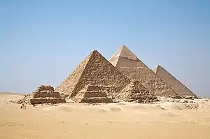 |
Kahire, 30°03′00″K 31°15′40″D |
Kültürel: (i)(v)(vi) |
16,35852 (40,4228) | 1979 | Mısır Eski Krallığı'nın başkenti kaya mezarları, süslü mastabalar, tapınaklar ve piramitler de dahil olmak üzere bazı olağanüstü mezar anıtlarına sahiptir. Eski zamanlarda, site Dünyanın Yedi Harikası'ndan biri olarak kabul edildi.[14] |
| Ebu Simbel'den Filai'ye Nübye Anıtları | 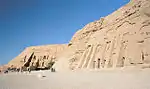 |
Asvan, 22°20′11″K 31°37′34″D |
Kültürel: (i)(iii)(vi) |
374 (920) | 1979 | Nil boyunca yer alan site, Ebu Simbel'deki II. Ramses Tapınağı ve Philae'deki Isis Tapınağı gibi Aswan Barajı'nın inşaatı sonucunda Nasser Gölü tarafından su altında kalmaktan kurtarılan anıtlar içeriyor.[15] |
| Azize Katerina Manastırı | 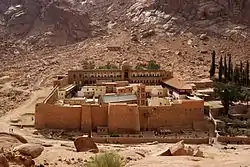 |
Güney Sina, 28°33′22″K 33°58′32″D |
Kültürel: (i)(iii)(iv)(vi) |
60.100 (149.000) | 2002 | Aziz Catherine Manastırı hala faaliyette olan en eski manastırlardan biridir. 6. Yüzyıldan beri, Eski Ahit'e göre Musaya Yasa Tabletlerinin gönderildiği Horeb Dağının yakınındadır. Bölge Hristiyanlar, müslümanlar ve yahudiler için kutsaldır.[16] |
| Vadi el-Hitan (Balinalar Vadisi) |  |
Feyyum , 29°20′00″K 30°11′00″D |
Doğal: (viii) |
20.015 (49.460) | 2005 | Batı Mısırda yer alan Balinalar Vadisi balinaların evriminin karasal hayvanlardan suda yaşayan memelilere evrildiğini gösteren soyu tükenmiş Archaeoceti fosilleri içerir.[17] |
| Güney Irak'taki Ahvar: Mezopotamya Şehirlerindeki Biyoçeşitliliğin Sığınağı ve Relikti Peyzajı | 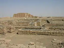 |
31°33′44″K 47°39′28″D |
Karma: (iii)(v)(ix)(x) |
211.544 (522.740) | 2016 | Located in southern Iraq, the site contains three cities of Sumerian origin, namely Uruk, Ur and Eridu, in addition to four wetland areas in the Iraqi Marshlands.[18] Güney Irak'ta bulunan alanda Uruk, Ur ve Eridu adında 3 Sümer şehrine ek olarak 4 bataklık bulunur. |
| Erbil Kalesi | 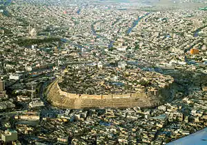 |
Erbil, 36°11′28″K 44°00′33″D |
Kültürel: (iv) |
16 (40) | 2014 | Irak Kürdistanı'ndaki bir tepede yer alan ve Erbil şehrine tepeden bakan Erbil Kalesi, Osmanlı dönemi şehir planlamasının tipik bir örneğini oluşturuyor. Bölgede 19. yüzyıl surlarının yanı sıra Asur dönemine ait kalıntılar da bulunmaktadır.[19] |
| Asur (Şarkat Kalesi) | .jpg.webp) |
Selahaddin, 35°27′32″K 43°15′35″D |
Kültürel: (iii)(iv) |
70 (170) | 2003 | Located on the Tigris and dating from the 3rd millennium BCE, Ashur was the first capital of the Assyrian Empire and the religious centre of the Assyrians. Following its destruction by the Babylonians, the city was briefly revived during the Parthian period.[20] |
| Hatra | 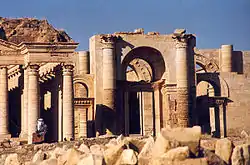 |
Ninova, 35°35′17″K 42°43′06″D |
Kültürel: (ii)(iii)(iv)(vi) |
324 (800) | 1985 | The fortified Parthian city of Hatra withstood repeated attacks by the Roman Empire in the 2nd century. Its architecture reflects both Hellenistic and Roman influences.[21] |
| Samarra Antik Kenti | 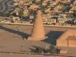 |
Selahaddin, 34°20′28″K 43°49′25″D |
Kültürel: (ii)(iii)(iv) |
15.058 (37.210) | 2007 | Located on the Tigris, the Islamic city of Samarra was the capital of the Abbasid Caliphate. It contains two of the largest mosques and several of the largest palaces in the Islamic world, in addition to being among the finest example of Abbasid-era town-planning.[22] |
| Tarihi Kudüs Şehri ve Duvarları | .jpg.webp) |
Kudüs 31°46′00″K 35°13′00″D |
Kültürel: (ii)(iii)(vi) |
— | 1981 | A holy city for three of the world's major religions, Jerusalem contains more than 200 historic monuments, including the Dome of the Rock, the Wailing Wall and the Church of the Holy Sepulchre.[23] |
| "Ürdün Ötesinde Bethany" Vaftiz Siti (Al-Maghtas) | .JPG.webp) |
31°50′14″K 35°33′10″D |
Kültürel: (iii)(vi) |
294 (730) | 2015 | Situated on the Jordan River, Al-Maghtas is considered the location of the Baptism of Jesus by John the Baptist. A Christian pilgrimage site, it contains remains of Roman and Byzantine churches, chapels, a monastery, caves and pools.[24] |
| Petra | _-_Petra%252C_Jordan_-_14_Oct._2009.jpg.webp) |
Ma'an, 30°19′50″K 35°26′36″D |
Kültürel: (i)(iii)(iv) |
— | 1985 | The Nabataean city of Petra was a major trading hub between Arabia, Egypt and Syria-Phoenicia, famed for its rock-cut architecture as well as its mining and water engineering systems.[25] |
| Kuseyr Amra | 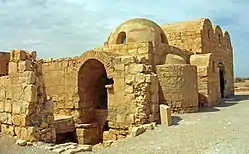 |
Zarqa, 31°48′7″K 36°35′9″D |
Kültürel: (i)(iii)(iv) |
— | 1985 | The desert castle of Quseir Amra was built in the early 8th century, and had served both as a fortress and a Umayyad royal palace. The site also noted for its extensive frescoes, constituting an important and unique example of early Islamic art.[26] |
| Umm ar-Rasas (Kastrom Mefa'a) | 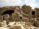 |
Madaba, 31°30′6″K 35°55′14″D |
Kültürel: (i)(iv)(vi) |
24 (59) | 2005 | Established as a Roman military camp, Um er-Rasas grew into a settlement by the 5th century, inhabited successively by Christian and Islamic communities. The largely unexcavated site contains ruins of Roman fortifications, churches with well-preserved mosaic floors and two stylite towers.[27] |
| Rum Vadisi Koruma Alanı | 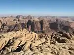 |
29°38′23″K 35°26′02″D |
Karma: (iii)(v)(vii) |
74.180 (183.300) | 2005 | Situated in southern Jordan, Wadi Rum features a great variety of desert landforms including sandstone valleys, natural arches, gorges, cliffs, landslides and caverns. The site also contains extensive rock art, inscriptions and archaeological remains, bearing witness to more than 12,000 years of continuous human habitation.[28] |
| Encer | 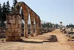 |
Bekaa, 33°43′33″K 35°55′47″D |
Kültürel: (iii)(iv) |
— | 1984 | Established in the early 8th century, the city of Anjar was quickly abandoned following the fall of the Umayyad Caliphate, leaving behind ruins of walls, towers, palaces, mosques and baths, constituting an example of Umayyad period town-planning.[29] |
| Baalbek | 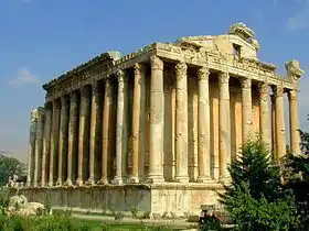 |
Bekaa, 34°00′25″K 36°12′18″D |
Kültürel: (i)(iv) |
— | 1984 | Previously known as Heliopolis, the Phoenician city of Baalbek hosts some of the largest and best preserved Roman temples, including the Temples of Jupiter, Venus and Bacchus.[30] |
| Biblos | 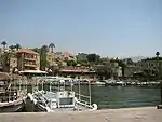 |
Cebel-i Lübnan, 34°07′09″K 35°38′51″D |
Kültürel: (iii)(iv)(vi) |
— | 1984 | Continuously inhabited since the Neolithic Era, Byblos was one of the oldest cities of Phoenician origin. It has since witness Persian, Roman, Crusader and Ottoman occupation, each exerting influence upon its architecture. Byblos also played a significant role in the diffusion of the Phoenician alphabet.[31] |
| Kutsal Vadi ve Tanrı'nın Sedirleri |  |
Şimal İli, 34°14′36″K 36°02′56″D |
Kültürel: (iii)(iv) |
— | 1998 | The Qadisha Valley has provided shelter for Christian communities since the beginnings of Christianity, hosting a large number of monasteries and hermitages. The Forest of the Cedars of God is among the last locations where Cedrus libani still grows, historically one of the most prized construction materials.[32] |
| Sur | 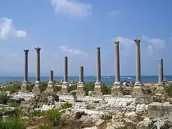 |
Cenub ili, 33°16′19″K 35°11′40″D |
Kültürel: (iii)(vi) |
154 (380) | 1984 | The ancient Phoenician city of Tyre was one of the foremost maritime powers in the eastern Mediterranean and reportedly where purple dye was discovered. Extant archaeological remains mainly date back to Roman times, including baths, an arena, a colonnaded road, a triumphal arch, an aqueduct and a hippodrome.[33] |
| Cyrene Antik Kenti | 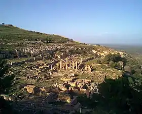 |
Jabal al Akhdar, 32°49′30″K 21°51′30″D |
Kültürel: (ii)(iii)(vi) |
— | 1982 | The formerly Greek colony of Cyrene was Romanized and transformed into a capital, until it was destroyed by the 365 Crete earthquake. The thousand-year-old ruins have remained renowned since the 18th century.[34] |
| Leptis Magna Antik Kenti | 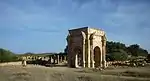 |
Khoms, 32°38′18″K 14°17′35″D |
Kültürel: (i)(ii)(iii) |
— | 1982 | The Roman city of Leptis Magna was enlarged by Emperor Septimius Severus, who was born there. Public monuments, a harbour, a marketplace, storehouses, shops, and homes were among the reasons for its induction into the list.[35] |
| Sabratha Antik Kenti | 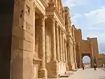 |
Zawiya, 32°48′19″K 12°29′06″D |
Kültürel: (iii) |
— | 1982 | Founded as a Phoenician trading post, Sabratha was briefly ruled by Masinissa of Numidia before its Romanization and reconstruction in the 2nd and 3rd centuries.[36] |
| Tarihi Ghadames Şehri | 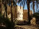 |
Nalut, 30°08′00″K 9°30′00″D |
Kültürel: (v) |
— | 1986 | Located in an oasis, Ghadames is among the oldest of pre-Saharan cities and represents a traditional domestic architecture with vertical division of functions.[37] |
| Tadrart Acacus Kaya Resimleri | 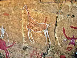 |
Fizan, 24°50′00″K 10°20′00″D |
Kültürel: (iii) |
— | 1985 | The massif of Tadrart Acacus contains thousands of cave paintings in different styles, dating from 12,000 BCE to 100 CE, reflecting changes of flora and fauna in the region as well as different lifestyles of successive populations in the Sahara.[38] |
| Ouadane, Chinguetti, Tichitt ve Oualata Antik Ksarları | 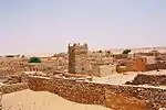 |
Ouadane, Chinguetti, Tichitt, ve Oualata, 20°55′44″K 11°37′25″B |
Kültürel: (iii)(iv)(v) |
— | 1996 | These four settlements were founded in the 11th and 12th centuries, originally meant to serve caravan trade routes across the Sahara. They gradually evolved into Islamic cultural centres, bearing witness to the nomadic lifestyle of the populations of western Sahara.[39] |
| Banc d'Arguin Ulusal Parkı | 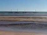 |
Nouadhibou ve Azefal, 20°14′05″K 16°06′32″B |
Doğal: (ix)(x) |
1.200.000 (3.000.000) | 1989 | The park consists of sand dunes, coastal swamps, small islands, and shallow bodies of water; all bordering the coast of the Atlantic Ocean. Birds are often found to migrate in the area, accompanied by various species of sea turtles and dolphins, whose presence fishermen often use to attract fish.[40] |
| Volubilis Antik Kenti | 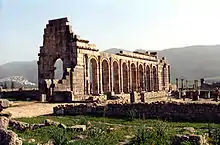 |
Fès-Meknès, 34°04′26″K 5°33′25″B |
Kültürel: (ii)(iii)(iv)(vi) |
42 (100) | 1997 | The important Roman outpost of Volubilis was founded in the 3rd century BCE as the capital of Mauretania, later becoming the capital of the Idrisid dynasty. It contained many buildings, the remains of which have survived extensively to this day.[41] |
| Tarihi Meknes Şehri | 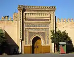 |
Fès-Meknès, 33°53′00″K 5°33′30″B |
Kültürel: (iv) |
— | 1996 | The former capital of the Alaouite dynasty was founded in the 11th century by the Almoravids and turned into a city with Spanish-Moorish influence during the 17th and 18th centuries.[42] |
| Ait-Ben-Haddou'daki Berberi Evleri | 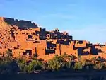 |
Drâa-Tafilalet, 31°02′50″K 7°07′44″B |
Kültürel: (iv)(v) |
3 (7,4) | 1987 | The Ksar of Ait-Ben-Haddou is an example of a traditional pre-Saharan habitat in southern Morocco, surrounded by high walls and reinforced with corner towers.[43] |
| Tarihi Essaouira (eski Mogador) Şehri | 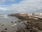 |
Marrakesh-Safi, 31°31′00″K 9°46′10″B |
Kültürel: (ii)(iv) |
30 (74) | 2001 | Built during the late 18th century, the fortified seaport of Essaouira has a mix of North African and European architecture, and was a major trading hub between the Sahara and Europe.[44] |
| Tarihi Fez Şehri | 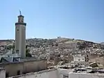 |
Fez, 34°03′40″K 4°58′40″B |
Kültürel: (ii)(v) |
280 (690) | 1981 | Fez was founded in the 9th century and reached its apogee as the capital of the Marinid dynasty in the 13th and 14th centuries, from which its urban fabric and major monuments date. It also hosts the world's oldest university, the University of Al Quaraouiyine.[45] |
| Tarihi Marakeş Şehri | 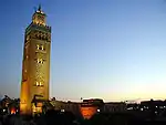 |
Marrakesh-Safi, 31°37′53″K 7°59′12″B |
Kültürel: (i)(ii)(iv)(v) |
1.107 (2.740) | 1985 | Marrakesh was founded in the 1070s and remained a political, economic, and cultural centre for a long time. Monuments from that period include the Koutoubia Mosque, the kasbah, and the battlements. The city also holds newer features, including palaces and madrasas.[46] |
| Tarihi Tétouan (eski Titawin) Şehri | 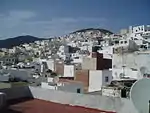 |
Tanger-Tetouan-Al Hoceima, 35°34′15″K 5°22′00″B |
Kültürel: (ii)(iv)(v) |
7 (17) | 1997 | Morocco's most complete medina at Tétouan served as the main point of contact between Morocco and Andalusia during the 8th century. The town was rebuilt by Andalusian refugees following the Reconquista, the influence of which is evident in its art and architecture.[47] |
| Rabat, Modern Başkent ve Tarihi Şehir: Paylaşılan Miras | 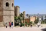 |
Rabat, 34°01′27″K 6°49′22″B |
Kültürel: (ii)(iv) |
349 (860) | 2012 | Rebuilt under the direction of the French from 1912 to the 1930s, Rabat blends historic and modern features, such as botanical gardens, the Hassan Mosque, and the remnants of Moorish and Andalusian settlements from the 17th century.[48] |
| Mazagan; Portekiz Sömürge Şehri (El Jadida) | 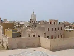 |
Casablanca-Settat, 33°15′24″K 8°30′07″B |
Kültürel: (ii)(iv) |
8 (20) | 2004 | The Portuguese fortification of Mazagan, akin to early Renaissance military design from the early 16th century, was taken over by Morocco in 1769. Surviving buildings include the cistern and a Gothic church.[49] |
| Umman Kehrizi | .jpg.webp) |
Dahiliye, Şarkiya veBatina Bölgeleri, 22°59′56″K 57°32′10″D |
Kültürel: (v) |
1.456 (3.600) | 2006 | The five Aflaj systems inscribed represents an irrigation method dating back to at least 500 CE. Such system effectively distribute water through gravity, as it flows to support agricultural and domestic use.[50] |
| Bat, Al-Khutm ve Al-Ayn Arkeolojik Siteleri |  |
Ad Zahira valiliği, 23°16′11″K 56°44′42″D |
Kültürel: (iii)(iv) |
— | 1988 | Located in the interior of the Sultanate, Bat, al-Khutm and al-Ayn are among the best preserved ensembles of settlements and necropolises from the 3rd millennium BCE in Eastern Arabia and the world. The necropolis of Bat, in particular, reflects the funeral practices of the Early Bronze Age in Oman.[51] |
| Bahla Kalesi | 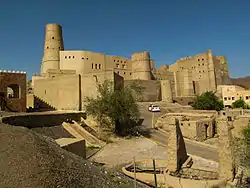 |
Ed Dahiliye valiliği, 22°57′51″K 57°18′04″D |
Kültürel: (iv) |
— | 1987 | The fort is part of Bahla, an oasis settlement and formerly the capital of the Nabhani dynasty, who dominated Oman and prospered in the Arabian Peninsula during the Late Middle Ages.[52] |
| Frankincense Toprakları | 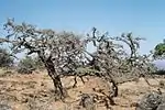 |
Zufar valiliği, 18°15′12″K 53°38′51″D |
Kültürel: (iii)(iv) |
850 (2.100) | 2000 | The ancient ports of Khor Rori and Al-Baleed, the caravan oasis of Shisr and Wadi Dawkah in southern Arabia were crucial in the production and distribution of frankincense, one of the most sought-after items of luxury in Antiquity.[53] |
| İsa'nın Doğum Yeri, Doğum Yeri Kilisesi ve Hac Yolu, Beytüllahim | 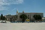 |
Beytüllahim, 31°42′16″K 35°12′27″D |
Kültürel: (ii)(iii) |
3 (7,4) | 2012 | The site is traditionally identified as the birthplace of Jesus. The church, built in the 4th century and reconstructed in the 6th century, holds prominent religious significance to both Christians and Muslims.[54] |
| Filistin, Zeytin ve Üzüm Toprakları, Güney Kudüs Kültürel Peyzajı, Battir | 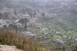 |
Beytüllahim, 31°43′11″K 35°07′50″D |
Kültürel: (iv)(v) |
349 (860) | 2014 | The hill landscape of Battir features stone terraces for market garden, grapevine and olive production, supported by a traditional irrigation system.[55] |
| Al Zubarah Antik Kenti | 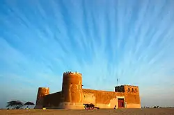 |
Medinet eş Şemal, 25°58′41″K 51°01′47″D |
Kültürel: (iii)(iv)(v) |
416 (1.030) | 2013 | [56] |
| El Hicr Antik Kenti | .jpg.webp) |
Medine Bölgesi, 26°47′01″K 37°57′18″D |
Kültürel: (ii)(iii) |
1.621 (4.010) | 2008 | Formerly known as Hegra, the site of Al-Hijr constitutes the largest settlement of the Nabataean Kingdom after Petra. It contains a series of well-preserved rock-cut tombs and monuments dating back to the 1st century BCE.[57] |
| Ad-Dir'iyah'taki At-Turaif Şehri | 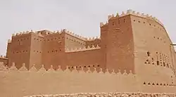 |
Riyad Bölgesi, 24°44′03″K 46°34′21″D |
Kültürel: (ii)(iii) |
29 (72) | 2008 | Founded in the 15th century, the Turaif District of Dir'iyah was the first capital of the Saudi dynasty. Dir'iyah witnessed the growth of its political and religious significance, as well as the spread of Wahhabism in the 18th and the early 19th centuries.[58] |
| Tarihi Cidde, Mekke'ye Açılan Kapı | 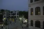 |
Mekke Bölgesi, 21°29′02″K 39°11′15″D |
Kültürel: (ii)(iv)(vi) |
18 (44) | 2014 | Located on the coast of the Red Sea, Jeddah grew into a major commercial centre in the 7th century, and has long served as the principal gateway for pilgrims to Mecca.[59] |
| Hail Bölgesi'ndeki Kaya Sanatı | Hail Bölgesi, 28°00′38″K 40°54′47″D |
Kültürel: (i)(iii) |
2,044 (5,05) | 2015 | The sites of Jabel Umm Sinman and Jabal al-Manjor and Raat contain a large number of petroglyphs and inscriptions, covering 10,000 years of human history.[60] | |
| Meroe Adası Antik Kenti | 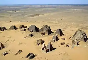 |
Nil Nehri Eyaleti, 16°56′00″K 33°43′00″D |
Kültürel: (ii)(iii)(iv)(v) |
2.357 (5.820) | 2011 | Meroe was the centre of the Kingdom of Kush, a major force active from the 8th century BCE to the 4th century CE. It is home to pyramids, temples, and domestic buildings, among other vestiges.[61] |
| Gebel Barkal ve Napatan Bölgesi'ndeki Anıtlar | 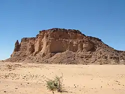 |
Kuzey Eyaleti, 18°32′00″K 31°49′00″D |
Kültürel: (i)(ii)(iii)(iv)(vi) |
183 (450) | 2003 | The archaeological sites of Gebel Barkal, Kurru, Nuri, Sanam and Zuma in the Nile Valley testify to the Napatan and Meroitic civilisations. They host a series of pyramids, tombs, temples, palaces, burial mounds and funerary chambers.[62] |
| Sanganeb Marine Ulusal Parkı ve Dungonab Koyu - Mukkawar Adası Deniz Ulusal Parkı | 19°44′10″K 37°26′35″D |
Doğal: (vii)(ix)(x) |
199.524 (493.030) | 2016 | Situated in the central Red Sea, Sanganeb, Dungonab Bay and Mukkawar Island feature a diverse system of coral reefs, mangroves, seagrass beds, beaches and islets, and host populations of seabirds, marine mammals, fish, sharks, turtles, manta rays and dugongs.[63] | |
| Tarihi Halep Şehri | 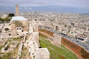 |
Halep, 36°14′00″K 37°10′00″D |
Kültürel: (iii)(iv) |
350 (860) | 1986 | Situated at the crossroads of several trade routes, Aleppo has been successively ruled, among others, by the Romans, Ayyubids, Mameluks and Ottomans, each leaving significant influence in its architectural fabric, resulting in a diverse cityscape. Major structures include the Citadel, the Great Mosque and the Madrasa Halawiye.[64] |
| Tarihi Busra Şehri | 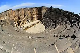 |
Dera, 32°31′05″K 36°28′54″D |
Kültürel: (i)(iii)(vi) |
— | 1980 | Formerly a Nabataean settlement, Bosra was conquered by the Romans in the 2nd century CE and made capital of Arabia. It came under Islamic rule in the 7th century. Remains of the ancient city include a theatre, a basilica, a cathedral, a mosque and a madrasa, among others.[65] |
| Tarihi Şam Şehri | 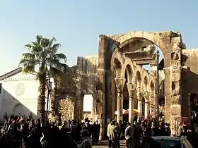 |
Şam, 33°30′41″K 36°18′23″D |
Kültürel: (i)(ii)(iii)(iv)(vi) |
86 (210) | 1979 | Established the 3rd millennium BCE, Damascus is considered to be one of the oldest continuously inhabited cities in the world. As the capital of the Umayyads, it has been of significant influence to the Arab world. The Great Mosque is among the largest in the world and the oldest sites of continuous prayer since the beginnings of Islam.[66] |
| Kuzey Suriye'nin Antik Köyleri | 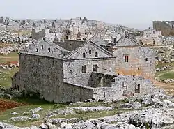 |
36°20′03″K 36°50′39″D |
Kültürel: (iii)(iv)(v) |
12.290 (30.400) | 2011 | The site comprises some 40 villages, dating from the 1st to 7th centuries and abandoned in the 8th to 10th centuries. They provide an insight into rural life in Late Antiquity and during the Byzantine period.[67] |
| Krak des Chevaliers ve Salah Ed-Din Kalesi | 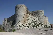 |
Humus ve Lazkiye İlleri, 34°46′54″K 36°15′47″D |
Kültürel: (ii)(iv) |
9 (22) | 2006 | The Crac des Chevaliers and the Qal'at Salah El-Din are regarded as two of the most prominent examples of castles during the Crusader period, demonstrating an evolution of fortifications and exchange of influences in defensive technology.[68] |
| Palmira Antik Kenti | 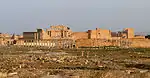 |
Humus, 34°33′15″K 38°16′00″D |
Kültürel: (i)(ii)(iv) |
0,36 (0,89) | 1980 | Palmyra came under Roman rule in the 1st century CE, and grew to become one of the most important cultural centres of the ancient world. Its extensive ruins include remains of the Great Colonnade, the Temple of Bel, the Camp of Diocletian and the Roman Theatre.[69] |
| Kartaca | 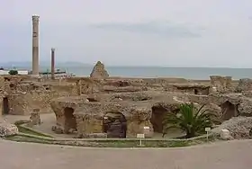 |
Tunus, 36°51′10″K 10°19′24″D |
Kültürel: (ii)(iii)(vi) |
616 (1.520) | 1979 | Founded in the 9th century BCE, Carthage developed into a trading empire spanning the Mediterranean. The city was destroyed in 146 BCE in the Punic Wars at the hands of the Romans, but was later reestablished.[70] |
| Dougga | 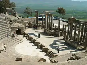 |
Bace, 36°25′25″K 9°13′13″D |
Kültürel: (ii)(iii) |
70 (170) | 1997 | The site features the ruins of Dougga, a former capital of a Libyan–Punic state, which flourished under the Romans and the Byzantines, but went into decline in the Islamic period.[71] |
| El Cem Amfitiyatrosu | 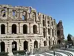 |
Mehdiye, 35°17′47″K 10°42′25″D |
Kültürel: (iv)(vi) |
1,37 (3,4) | 1979 | Built during the 3rd century, the Amphitheatre of El Jem is North Africa's largest amphitheatre, and the largest one built outside of Italy, with a capacity of 35,000 spectators, regarded as among the most accomplished examples of Roman architecture of its kind.[72] |
| Ichkeul Milli Parkı |  |
Bizerte, 37°09′49″K 9°40′29″D |
Doğal: (x) |
12.600 (31.000) | 1980 | Ichkeul Lake and the surrounding wetlands is a destination for hundreds of thousands of migrating birds, including ducks, geese, storks and pink flamingos. It was once part of a chain that extended across North Africa.[73] |
| Kayravan | 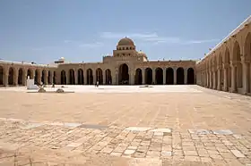 |
Kayravan, 35°40′54″K 10°06′14″D |
Kültürel: (i)(ii)(iii)(v)(vi) |
68 (170) | 1988 | Founded in 670, Kairouan was the former capital of Ifriqiya and flourished in the 9th century. Its heritage includes the Mosque of Uqba and the Mosque of the Three Gates.[74] |
| Tarihi Sus Şehri | 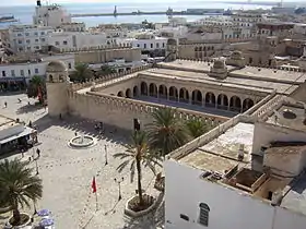 |
Susa, 35°49′40″K 10°38′19″D |
Kültürel: (iii)(iv)(v) |
32 (79) | 1988 | A prime example of a town from the early Islamic period, Sousse was an important commercial and military port during the 9th century.[75] |
| Tarihi Tunus Şehri | 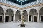 |
Tunus, 36°49′00″K 10°10′00″D |
Kültürel: (ii)(iii)(v) |
296 (730) | 1979 | The Medina of Tunis contains some 700 monuments, including palaces, mosques, mausoleums, madrasah and fourtains, testifying to Tunis' golden age from the 12th to the 16th century.[76] |
| Kerkouane Antik Kenti ve Nekropolü | 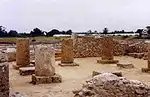 |
Nabil, 36°56′47″K 11°05′57″D |
Kültürel: (iii) |
— | 1985 | Abandoned in 250 BCE during the First Punic War and never rebuilt, Kerkuane is the only surviving example of a Phoenicio–Punic settlement.[77] |
| El Ayn Kültürel Sitleri (Hafit, Hili, Bidaa Bint Saud ve Vaha Bölgeleri) | 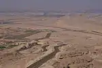 |
Abu Dabi Emirliği, 24°04′04″K 55°48′23″D |
Kültürel: (iii)(iv)(v) |
4.945 (12.220) | 2011 | Situated in a desert region, Al Ain has been occupied since the Neolithic period, hosting stone tombs from the 3rd millennium BCE, wells, adobe constructions and one of the oldest examples of the aflaj irrigation system.[78] |
| Tarihi Zabid Şehri |  |
El-Hudeyde, 14°11′53″K 43°19′48″D |
Kültürel: (iii) |
— | 1993 | Zabid was the capital of Yemen from the 13th to the 15th century. Its Islamic university greatly contributed to the spread of Islamic knowledge.[79] |
| Tarihi San'a Şehri | 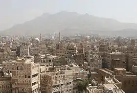 |
San'a, 15°21′20″K 44°12′29″D |
Kültürel: (iv)(v)(vi) |
— | 1986 | Situated in a mountain valley, Sana'a has been continuously inhabited for more than 2,500 years. It became a centre for the spread of Islam in the 7th and 8th centuries. The city is home to the unique rammed-earth tower-houses, in addition to 103 mosques and 14 hammams built before the 11th century.[80] |
| Tarihi Şibam Şehri | 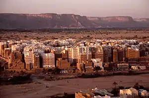 |
Hadramut, 15°55′37″K 48°37′36″D |
Kültürel: (iii)(iv)(v) |
— | 1982 | The 16th-century walled city of Shibam is among the oldest and best examples of vertical urban planning, with its distinct mud brick tower houses garnering it the nickname "the Manhattan of the desert".[81] |
| Socotra Adası | 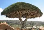 |
Hadramut, 12°30′00″K 53°50′00″D |
Doğal: (x) |
410.460 (1.014.300) | 2008 | The Socotra Archipelago is known for its great biodiversity and distinct flora and fauna, with a large number of endemic species found nowhere else on earth. It also supports a broad range of avian and marine life.[82] |
- "World Heritage Centre - World Heritage List". 3 Mart 2015 tarihinde kaynağından arşivlendi. Erişim tarihi: 11 Haziran 2017.
- "Al Qal'a of Beni Hammad". UNESCO. 23 Haziran 2017 tarihinde kaynağından arşivlendi. Erişim tarihi: 17 Ağustos 2011.
- "Djémila". UNESCO. 23 Haziran 2017 tarihinde kaynağından arşivlendi. Erişim tarihi: 17 Ağustos 2011.
- "Kasbah of Algiers". UNESCO. 23 Haziran 2017 tarihinde kaynağından arşivlendi. Erişim tarihi: 17 Ağustos 2011.
- "M'zab Valley". UNESCO. 23 Haziran 2017 tarihinde kaynağından arşivlendi. Erişim tarihi: 17 Ağustos 2011.
- "Tassili n'Ajjer". UNESCO. 23 Haziran 2017 tarihinde kaynağından arşivlendi. Erişim tarihi: 17 Ağustos 2011.
- "Timgad". UNESCO. 23 Haziran 2017 tarihinde kaynağından arşivlendi. Erişim tarihi: 17 Ağustos 2011.
- "Tipaza". UNESCO. 23 Haziran 2017 tarihinde kaynağından arşivlendi. Erişim tarihi: 17 Ağustos 2011.
- "Qal'at al-Bahrain – Ancient Harbour and Capital of Dilmun". UNESCO. 23 Haziran 2017 tarihinde kaynağından arşivlendi. Erişim tarihi: 17 Ağustos 2011.
- "Pearling, Testimony of an Island Economy". UNESCO. 23 Haziran 2017 tarihinde kaynağından arşivlendi. Erişim tarihi: 1 Temmuz 2012.
- "Ancient Thebes with its Necropolis". UNESCO. 23 Haziran 2017 tarihinde kaynağından arşivlendi. Erişim tarihi: 17 Ağustos 2011.
- "Memphis and its Necropolis – the Pyramid Fields from Giza to Dahshur". UNESCO. 23 Haziran 2017 tarihinde kaynağından arşivlendi. Erişim tarihi: 24 Aralık 2016.
- "Nubian Monuments from Abu Simbel to Philae". UNESCO. 23 Haziran 2017 tarihinde kaynağından arşivlendi. Erişim tarihi: 17 Ağustos 2011.
- "Saint Catherine Area". UNESCO. 23 Haziran 2017 tarihinde kaynağından arşivlendi. Erişim tarihi: 17 Ağustos 2011.
- "Wadi Al-Hitan (Whale Valley)". UNESCO. 9 Haziran 2017 tarihinde kaynağından arşivlendi. Erişim tarihi: 17 Ağustos 2011.
- "The Ahwar of Southern Iraq: Refuge of Biodiversity and the Relict Landscape of the Mesopotamian Cities". UNESCO. 10 Haziran 2017 tarihinde kaynağından arşivlendi. Erişim tarihi: 6 Ağustos 2016.
- "Erbil Citadel". UNESCO. 23 Haziran 2017 tarihinde kaynağından arşivlendi. Erişim tarihi: 2 Ocak 2015.
- "Ashur (Qal'at Sherqat)". UNESCO. 23 Haziran 2017 tarihinde kaynağından arşivlendi. Erişim tarihi: 17 Ağustos 2011.
- "Hatra". UNESCO. 23 Haziran 2017 tarihinde kaynağından arşivlendi. Erişim tarihi: 17 Ağustos 2011.
- "Samarra Archaeological City". UNESCO. 23 Haziran 2017 tarihinde kaynağından arşivlendi. Erişim tarihi: 17 Ağustos 2011.
- "Old City of Jerusalem and its Walls". UNESCO. 23 Haziran 2017 tarihinde kaynağından arşivlendi. Erişim tarihi: 17 Ağustos 2011.
- "Baptism Site "Bethany Beyond the Jordan" (Al-Maghtas)". UNESCO. 23 Haziran 2017 tarihinde kaynağından arşivlendi. Erişim tarihi: 6 Ekim 2015.
- "Petra". UNESCO. 10 Haziran 2017 tarihinde kaynağından arşivlendi. Erişim tarihi: 17 Ağustos 2011.
- "Qasr Amra". UNESCO. 23 Haziran 2017 tarihinde kaynağından arşivlendi. Erişim tarihi: 17 Ağustos 2011.
- "Um er-Rasas (Kastrom Mefa'a)". UNESCO. 23 Haziran 2017 tarihinde kaynağından arşivlendi. Erişim tarihi: 17 Ağustos 2011.
- "Wadi Rum Protected Area". UNESCO. 23 Haziran 2017 tarihinde kaynağından arşivlendi. Erişim tarihi: 17 Ağustos 2011.
- "Anjar". UNESCO. 23 Haziran 2017 tarihinde kaynağından arşivlendi. Erişim tarihi: 17 Ağustos 2011.
- "Baalbek". UNESCO. 23 Haziran 2017 tarihinde kaynağından arşivlendi. Erişim tarihi: 17 Ağustos 2011.
- "Byblos". UNESCO. 23 Haziran 2017 tarihinde kaynağından arşivlendi. Erişim tarihi: 17 Ağustos 2011.
- "Ouadi Qadisha (the Holy Valley) and the Forest of the Cedars of God (Horsh Arz el-Rab)". UNESCO. 23 Haziran 2017 tarihinde kaynağından arşivlendi. Erişim tarihi: 17 Ağustos 2011.
- "Tyre". UNESCO. 23 Haziran 2017 tarihinde kaynağından arşivlendi. Erişim tarihi: 17 Ağustos 2011.
- "Archaeological Site of Cyrene". UNESCO. 23 Haziran 2017 tarihinde kaynağından arşivlendi. Erişim tarihi: 17 Ağustos 2011.
- "Archaeological Site of Leptis Magna". UNESCO. 23 Haziran 2017 tarihinde kaynağından arşivlendi. Erişim tarihi: 17 Ağustos 2011.
- "Archaeological Site of Sabratha". UNESCO. 9 Haziran 2017 tarihinde kaynağından arşivlendi. Erişim tarihi: 17 Ağustos 2011.
- "Old Town of Ghadamès". UNESCO. 23 Haziran 2017 tarihinde kaynağından arşivlendi. Erişim tarihi: 17 Ağustos 2011.
- "Rock-Art Sites of Tadrart Acacus". UNESCO. 11 Haziran 2017 tarihinde kaynağından arşivlendi. Erişim tarihi: 17 Ağustos 2011.
- "Ancient Ksour of Ouadane, Chinguetti, Tichitt and Oualata". UNESCO. 23 Haziran 2017 tarihinde kaynağından arşivlendi. Erişim tarihi: 17 Ağustos 2011.
- "Banc d'Arguin National Park". UNESCO. 23 Haziran 2017 tarihinde kaynağından arşivlendi. Erişim tarihi: 17 Ağustos 2011.
- "Archaeological Site of Volubilis". UNESCO. 24 Aralık 2018 tarihinde kaynağından arşivlendi. Erişim tarihi: 17 Ağustos 2011.
- "Historic City of Meknes". UNESCO. 23 Haziran 2017 tarihinde kaynağından arşivlendi. Erişim tarihi: 17 Ağustos 2011.
- "Ksar of Ait-Ben-Haddou". UNESCO. 22 Haziran 2017 tarihinde kaynağından arşivlendi. Erişim tarihi: 17 Ağustos 2011.
- "Medina of Essaouira (formerly Mogador)". UNESCO. 23 Haziran 2017 tarihinde kaynağından arşivlendi. Erişim tarihi: 17 Ağustos 2011.
- "Medina of Fez". UNESCO. 24 Aralık 2018 tarihinde kaynağından arşivlendi. Erişim tarihi: 17 Ağustos 2011.
- "Medina of Marrakesh". UNESCO. 23 Haziran 2017 tarihinde kaynağından arşivlendi. Erişim tarihi: 17 Ağustos 2011.
- "Medina of Tétouan (formerly known as Titawin)". UNESCO. 23 Haziran 2017 tarihinde kaynağından arşivlendi. Erişim tarihi: 17 Ağustos 2011.
- "Rabat, Modern Capital and Historic City: a Shared Heritage". UNESCO. 23 Haziran 2017 tarihinde kaynağından arşivlendi. Erişim tarihi: 6 Şubat 2016.
- "Portuguese City of Mazagan (El Jadida)". UNESCO. 23 Haziran 2017 tarihinde kaynağından arşivlendi. Erişim tarihi: 17 Ağustos 2011.
- "Aflaj Irrigation Systems of Oman". UNESCO. 23 Haziran 2017 tarihinde kaynağından arşivlendi. Erişim tarihi: 17 Ağustos 2011.
- "Archaeological Sites of Bat, Al-Khutm and Al-Ayn". UNESCO. 23 Haziran 2017 tarihinde kaynağından arşivlendi. Erişim tarihi: 17 Ağustos 2011.
- "Bahla Fort". UNESCO. 23 Haziran 2017 tarihinde kaynağından arşivlendi. Erişim tarihi: 17 Ağustos 2011.
- "Land of Frankincense". UNESCO. 23 Haziran 2017 tarihinde kaynağından arşivlendi. Erişim tarihi: 17 Ağustos 2011.
- "Birthplace of Jesus: Church of the Nativity and the Pilgrimage Route, Bethlehem". UNESCO. 23 Haziran 2017 tarihinde kaynağından arşivlendi. Erişim tarihi: 12 Mayıs 2016.
- "Palestine: Land of Olives and Vines – Cultural Landscape of Southern Jerusalem, Battir". UNESCO. 23 Haziran 2017 tarihinde kaynağından arşivlendi. Erişim tarihi: 12 Mayıs 2016.
- "Al Zubarah Archaeological Site". UNESCO. 23 Haziran 2017 tarihinde kaynağından arşivlendi. Erişim tarihi: 3 Mayıs 2015.
- "Al-Hijr Archaeological Site (Madâin Sâlih)". UNESCO. 23 Haziran 2017 tarihinde kaynağından arşivlendi. Erişim tarihi: 17 Ağustos 2011.
- "At-Turaif District in ad-Dir'iyah". UNESCO. 23 Haziran 2017 tarihinde kaynağından arşivlendi. Erişim tarihi: 17 Ağustos 2011.
- "Historic Jeddah, the Gate to Makkah". UNESCO. 23 Haziran 2017 tarihinde kaynağından arşivlendi. Erişim tarihi: 12 Ekim 2015.
- "Rock Art in the Hail Region of Saudi Arabia". UNESCO. 23 Haziran 2017 tarihinde kaynağından arşivlendi. Erişim tarihi: 12 Ekim 2015.
- "Archaeological Sites of the Island of Meroe". UNESCO. 23 Haziran 2017 tarihinde kaynağından arşivlendi. Erişim tarihi: 17 Ağustos 2011.
- "Gebel Barkal and the Sites of the Napatan Region". UNESCO. 24 Aralık 2018 tarihinde kaynağından arşivlendi. Erişim tarihi: 17 Ağustos 2011.
- "Sanganeb Marine National Park and Dungonab Bay – Mukkawar Island Marine National Park". UNESCO. 23 Haziran 2017 tarihinde kaynağından arşivlendi. Erişim tarihi: 6 Ağustos 2016.
- "Ancient City of Aleppo". UNESCO. 23 Haziran 2017 tarihinde kaynağından arşivlendi. Erişim tarihi: 17 Ağustos 2011.
- "Ancient City of Bosra". UNESCO. 23 Haziran 2017 tarihinde kaynağından arşivlendi. Erişim tarihi: 17 Ağustos 2011.
- "Ancient City of Damascus". UNESCO. 23 Haziran 2017 tarihinde kaynağından arşivlendi. Erişim tarihi: 17 Ağustos 2011.
- "Ancient Villages of Northern Syria". UNESCO. 23 Haziran 2017 tarihinde kaynağından arşivlendi. Erişim tarihi: 17 Ağustos 2011.
- "Crac des Chevaliers and Qal'at Salah El-Din". UNESCO. 23 Haziran 2017 tarihinde kaynağından arşivlendi. Erişim tarihi: 17 Ağustos 2011.
- "Site of Palmyra". UNESCO. 21 Haziran 2017 tarihinde kaynağından arşivlendi. Erişim tarihi: 17 Ağustos 2011.
- "Archaeological Site of Carthage". UNESCO. 23 Haziran 2017 tarihinde kaynağından arşivlendi. Erişim tarihi: 17 Ağustos 2011.
- "Dougga / Thugga". UNESCO. 23 Haziran 2017 tarihinde kaynağından arşivlendi. Erişim tarihi: 17 Ağustos 2011.
- "Amphitheatre of El Jem". UNESCO. 23 Haziran 2017 tarihinde kaynağından arşivlendi. Erişim tarihi: 17 Ağustos 2011.
- "Ichkeul National Park". UNESCO. 23 Haziran 2017 tarihinde kaynağından arşivlendi. Erişim tarihi: 17 Ağustos 2011.
- "Kairouan". UNESCO. 23 Haziran 2017 tarihinde kaynağından arşivlendi. Erişim tarihi: 17 Ağustos 2011.
- "Medina of Sousse". UNESCO. 23 Haziran 2017 tarihinde kaynağından arşivlendi. Erişim tarihi: 17 Ağustos 2011.
- "Medina of Tunis". UNESCO. 23 Haziran 2017 tarihinde kaynağından arşivlendi. Erişim tarihi: 17 Ağustos 2011.
- "Punic Town of Kerkuane and its Necropolis". UNESCO. 23 Haziran 2017 tarihinde kaynağından arşivlendi. Erişim tarihi: 17 Ağustos 2011.
- "Cultural Sites of Al Ain (Hafit, Hili, Bidaa Bint Saud and Oases Areas)". UNESCO. 23 Haziran 2017 tarihinde kaynağından arşivlendi. Erişim tarihi: 6 Şubat 2016.
- "Historic Town of Zabid". UNESCO. 21 Haziran 2017 tarihinde kaynağından arşivlendi. Erişim tarihi: 17 Ağustos 2011.
- "Old City of Sana'a". UNESCO. 24 Haziran 2017 tarihinde kaynağından arşivlendi. Erişim tarihi: 17 Ağustos 2011.
- "Old Walled City of Shibam". UNESCO. 23 Haziran 2017 tarihinde kaynağından arşivlendi. Erişim tarihi: 17 Ağustos 2011.
- "Socotra Archipelago". UNESCO. 23 Haziran 2017 tarihinde kaynağından arşivlendi. Erişim tarihi: 17 Ağustos 2011.
This article is issued from Wikipedia. The text is licensed under Creative Commons - Attribution - Sharealike. Additional terms may apply for the media files.
