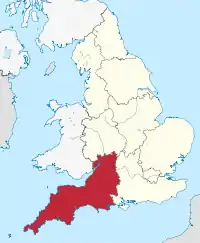
Güney Batı İngiltere
Güneybatı İngiltere (İngilizce: South West England), İngiltere'nin bölgelerinden biridir. Bölge, İngiltere'nin en büyük bölgesidir. Yüzölçümü 23,800 km² olan[1] bölgenin nüfusu 2011 yılı itibarı ile 5,289,000'dir.[2]
| Güneybatı İngiltere South West England | |
|---|---|
.jpg.webp) | |
| Ülke |
|
| Ülke |
|
| Yüzölçümü | |
| • Toplam | 23.800 km² (9.100 mil²) |
| Nüfus (2011) | |
| • Toplam | 5,289,000 |
| Zaman dilimi | UTC±00.00 (BAZD) |
| • Yaz (YSU) | UTC+01.00 (BAYZD) |
|
Resmî site www.swcouncils.gov.uk | |
İdari bölümler
| Harita | Törensel kontluk | Shire kontluğu / üniter | İlçe |
|---|---|---|---|
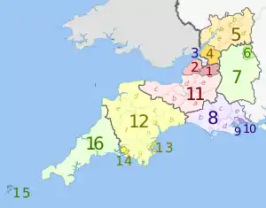 | Somerset | 1. Bath and North East Somerset UA | |
| 2. North Somerset UA | |||
| 11. Somerset CC | a) South Somerset, b) Taunton Deane, c) West Somerset, d) Sedgemoor, e) Mendip | ||
| 3. Bristol UA | |||
| Gloucestershire | 4. South Gloucestershire UA | ||
| 5. Gloucestershire CC | a) Gloucester, b) Tewkesbury, c) Cheltenham, d) Cotswold, e) Stroud, f) Forest of Dean | ||
| Wiltshire | 6. Swindon UA | ||
| 7. Wiltshire UA | |||
| Dorset | 8. Dorset CC | a) Weymouth and Portland, b) West Dorset, c) North Dorset, d) Purbeck, e) East Dorset, f) Christchurch | |
| 9. Poole UA | |||
| 10. Bournemouth UA | |||
| Devon | 12. Devon CC | a) Exeter, b) East Devon, c) Mid Devon, d) North Devon, e) Torridge, f) West Devon, g) South Hams, h) Teignbridge | |
| 13. Torbay UA | |||
| 14. Plymouth UA | |||
| Cornwall | 15. Isles of Scilly sui generis UA | ||
| 16. Cornwall UA | |||
UA = üniter otorite; CC = kontluk konseyi
Kaynakça
- "South West had the oldest population in the UK in 2012". Office for National Statistics. 17 Ekim 2013. 8 Aralık 2015 tarihinde kaynağından arşivlendi. Erişim tarihi: 7 Temmuz 2017.
- "2011 Census - Population and Household Estimates for England and Wales, March 2011" (PDF). Office for National Statistics. 2012. s. s. 13. 24 Şubat 2016 tarihinde kaynağından (PDF) arşivlendi. Erişim tarihi: 7 Temmuz 2017.
Dış bağlantılar
| Wikimedia Commons'ta South West England ile ilgili ortam dosyaları bulunmaktadır. |
This article is issued from Wikipedia. The text is licensed under Creative Commons - Attribution - Sharealike. Additional terms may apply for the media files.
