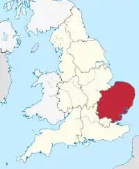
Doğu İngiltere
Doğu İngiltere (İngilizce: East of England), İngiltere'nin bölgelerinden biridir. Yüzölçümü 19,120 km² olan bölgenin nüfusu 2011 yılı itibarı ile 5,847,000'dir.[1]
| Doğu İngiltere East of England | |
|---|---|
| Ülke |
|
| Ülke |
|
| Yüzölçümü | |
| • Toplam | 19.120 km² (7.380 mil²) |
| Nüfus (2011) | |
| • Toplam | 5,847,000 |
| Zaman dilimi | UTC±00.00 (BAZD) |
| • Yaz (YSU) | UTC+01.00 (BAYZD) |
|
Resmî site www.eelga.gov.uk | |
İdari bölümler
| Harita | Törensel kontluk | Shire kontluğu / üniter | İlçe |
|---|---|---|---|
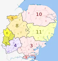 | Essex | 1. Thurrock U.A. | |
| 2. Southend-on-Sea U.A. | |||
| 3. Essex | a) Harlow, b) Epping Forest, c) Brentwood, d) Basildon, e) Castle Point, f) Rochford, g) Maldon, h) Chelmsford, i) Uttlesford, j) Braintree, k) Colchester, l) Tendring | ||
| 4. Hertfordshire | a) Three Rivers, b) Watford, c) Hertsmere, d) Welwyn Hatfield, e) Broxbourne, f) East Hertfordshire, g) Stevenage, h) North Hertfordshire, i) St Albans, j) Dacorum | ||
| Bedfordshire | 5. Luton U.A. | ||
| 6. Bedford U.A. | |||
| 7. Central Bedfordshire U.A. | |||
| Cambridgeshire | 8. Cambridgeshire | a) Cambridge, b) South Cambridgeshire, c) Huntingdonshire, d) Fenland, e) East Cambridgeshire | |
| 9. Peterborough U.A. | |||
| 10. Norfolk | a) Norwich, b) South Norfolk, c) Great Yarmouth, d) Broadland, e) North Norfolk, f) Breckland, g) King's Lynn and West Norfolk | ||
| 11. Suffolk | a) Ipswich, b) Suffolk Coastal, c) Waveney, d) Mid Suffolk, e) Babergh, f) St. Edmundsbury, g) Forest Heath | ||
Kaynakça
- "2011 Census - Population and Household Estimates for England and Wales, March 2011" (PDF). Office for National Statistics. 2012. 24 Şubat 2016 tarihinde kaynağından (PDF) arşivlendi. Erişim tarihi: 7 Temmuz 2017.
Dış bağlantılar
| Wikimedia Commons'ta East of England ile ilgili ortam dosyaları bulunmaktadır. |
This article is issued from Wikipedia. The text is licensed under Creative Commons - Attribution - Sharealike. Additional terms may apply for the media files.